Open Sea Adventures/maps: Difference between revisions
Jump to navigation
Jump to search
m (Adding the map of the Flotilla) |
FIREPHOENIX (talk | contribs) mNo edit summary |
||
| (13 intermediate revisions by 4 users not shown) | |||
| Line 4: | Line 4: | ||
This is a collection of Open Sea Adventures maps that have been used on this wiki. This listing is to give map users options as well as show older maps for timeline posterity. |
This is a collection of Open Sea Adventures maps that have been used on this wiki. This listing is to give map users options as well as show older maps for timeline posterity. |
||
== GM |
== GM Thandiwe's Master Expansion Map == |
||
[[Image:Southern Ocean.jpg | thumb | none | alt=Excel Map of OSA Expansion | Thandiwe's Expansion Map (March 2025).]] |
|||
| ⚫ | |||
[[Image:Southern Ocean - Higher Res.png|thumb|none|alt=Higher resolution map of OSA Expansion for Southern Ocean|Higher Resolution OSA Expansion for Southern Ocean<br>Map image created by uploader]] |
|||
== Brisker's Cove == |
|||
[https://docs.google.com/spreadsheets/d/15kT_GejRcSG_1K8FOMato1WtI-pLoAczKJXnCGSv0lo/edit?usp=sharing Spreadsheet Version of Map] |
|||
[[Image:Brisker's Cove.png | thumb | none | alt=A quick and dirty location image for Brisker's Cove | A quick and dirty location image for Brisker's Cove by Arianiss.]] |
|||
== GM Retser's Master Version == |
|||
The placement of Brisker's Cove (and Fairport) on the player created OSA map was done through careful consideration of official Elanith maps, and the existing locations of Solhaven and River's Rest on the in game map. I suspect the in game location of the Brisker's Cove port is wrong (it's too far south) and a bug report was submitted. This is a short term temporary image until I find out more details. |
|||
| ⚫ | |||
Also of note, the 3 blank areas with dots, around the port, are ocean rooms in game. |
|||
| ⚫ | |||
More information can be seen here: [[User:WINTERDAWN/Areas of Investigation#The Curious Case of Brisker's Cove (port location)]] |
|||
Prior versions of the full map were created with a wiki file size limit of 5mb. A wiki update caused this to downgrade to 2mb. Achieving this file size would severely compromise the quality of the map and so I'm going to use Google Drive to release the high quality version. |
|||
| ⚫ | |||
[[Image:Open Sea Adventures.jpg | thumb | none | alt=A |
[[Image:Open Sea Adventures (thumbnail).jpg | thumb | none | link=https://drive.google.com/file/d/1fAbK6zhFvGJv2uS0pvbfaZqaJD5mDmB5 | alt=A full version map of the accessible ocean by Arianiss. It has a parchment texture background, text labels for points of interest, and various graphics to give visual flair. It is accurate and complete as of May 2025. This is a thumbnail image that links to a Google Drive image due to the wiki upload file size limit. | Arianiss's version (May 2025). This map is accurate and complete as of May 2025. This is a thumbnail that links to Google Drive.]] |
||
[[Image:Open Sea Adventures (moderate).jpg | thumb | none | alt=A |
[[Image:Open Sea Adventures (moderate).jpg | thumb | none | alt=A moderate version map of the accessible ocean by Arianiss. It has a parchment texture background and text labels for points of interest. It removes the graphics that are in the full version. It is accurate and complete as of May 2025. | Arianiss's version (May 2025). This map is accurate and complete as of May 2025.]] |
||
[[Image:Open Sea Adventures (basic).png | thumb | none | alt=A |
[[Image:Open Sea Adventures (basic).png | thumb | none | alt=A basic version map of the accessible ocean by Arianiss. It has a white background. It removes the parchment texture background, text labels, and graphics that are in the full version. It is accurate and complete as of May 2025. | Arianiss's version (May 2025). This map is accurate and complete as of May 2025.]] |
||
| ⚫ | |||
| ⚫ | |||
== Naamit's Version (July 2021) == |
== Naamit's Version (July 2021) == |
||
| Line 48: | Line 52: | ||
[https://gswiki.play.net/images/archive/a/ac/20201113191429%21ElanthiaOcean.png Click Here to Open Retser's Version] |
[https://gswiki.play.net/images/archive/a/ac/20201113191429%21ElanthiaOcean.png Click Here to Open Retser's Version] |
||
[[Category: World]] |
|||
| ⚫ | |||
| ⚫ | |||
[[Category: Maps]] |
[[Category: Maps]] |
||
[[Category: Open Sea Adventures]] |
[[Category: Open Sea Adventures]] |
||
Latest revision as of 19:07, 23 February 2026
This article is a work in progress!
This is a collection of Open Sea Adventures maps that have been used on this wiki. This listing is to give map users options as well as show older maps for timeline posterity.
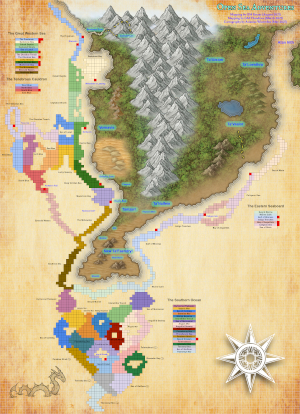
GM Thandiwe's Master Expansion Map


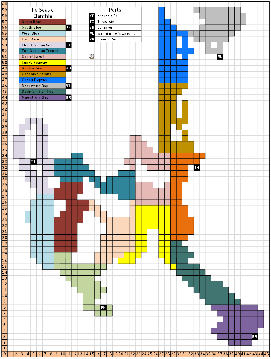
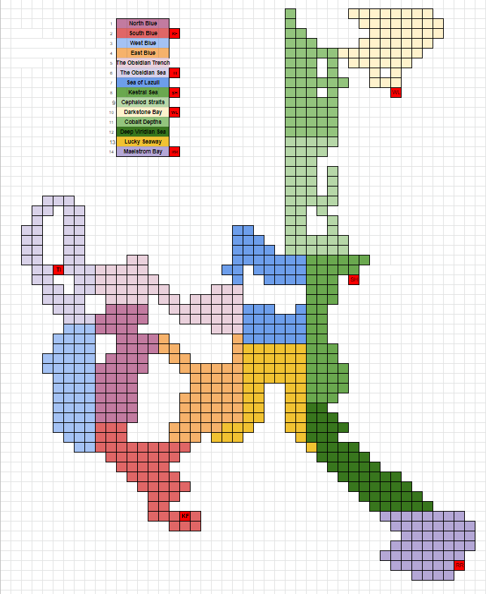
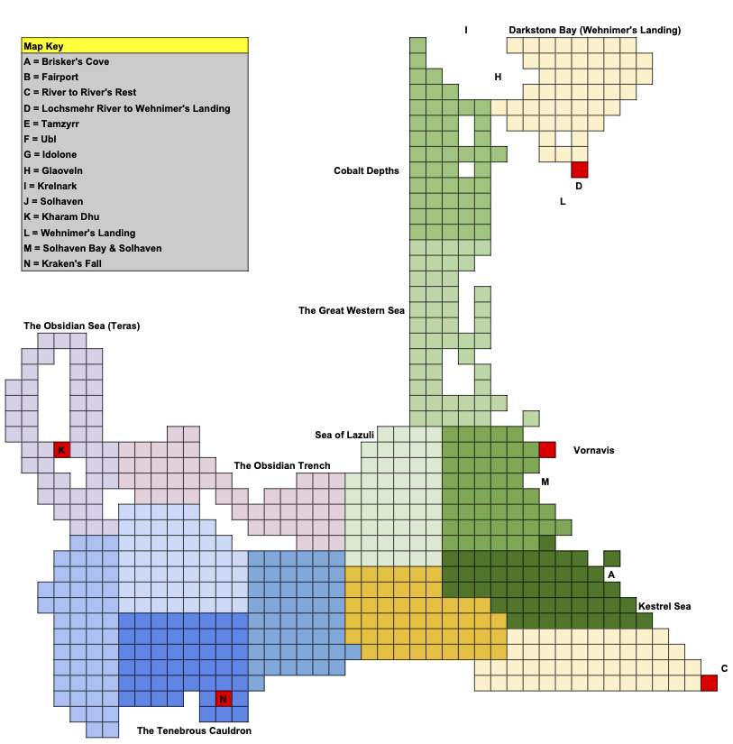
GM Retser's Master Version
Click Here to Open the Google Sheet
Arianiss's Version (May 2025)
Prior versions of the full map were created with a wiki file size limit of 5mb. A wiki update caused this to downgrade to 2mb. Achieving this file size would severely compromise the quality of the map and so I'm going to use Google Drive to release the high quality version.
.jpg)
.png)
Avery Trent's Map of the Flotilla (June 2023)

Naamit's Version (July 2021)

.jpg)
Athias's Version (January 2021)
This map is accurate but incomplete as of November 2022.
Click Here to Open Athias's Version
GM Retser's Original Version (November 2020)
This map is accurate but incomplete as of November 2022.
Click Here to Open Retser's Version
GM Retser's Original Version (July 2020)
This map is inaccurate. Do not use it. Listed for historical posterity.