Elanith
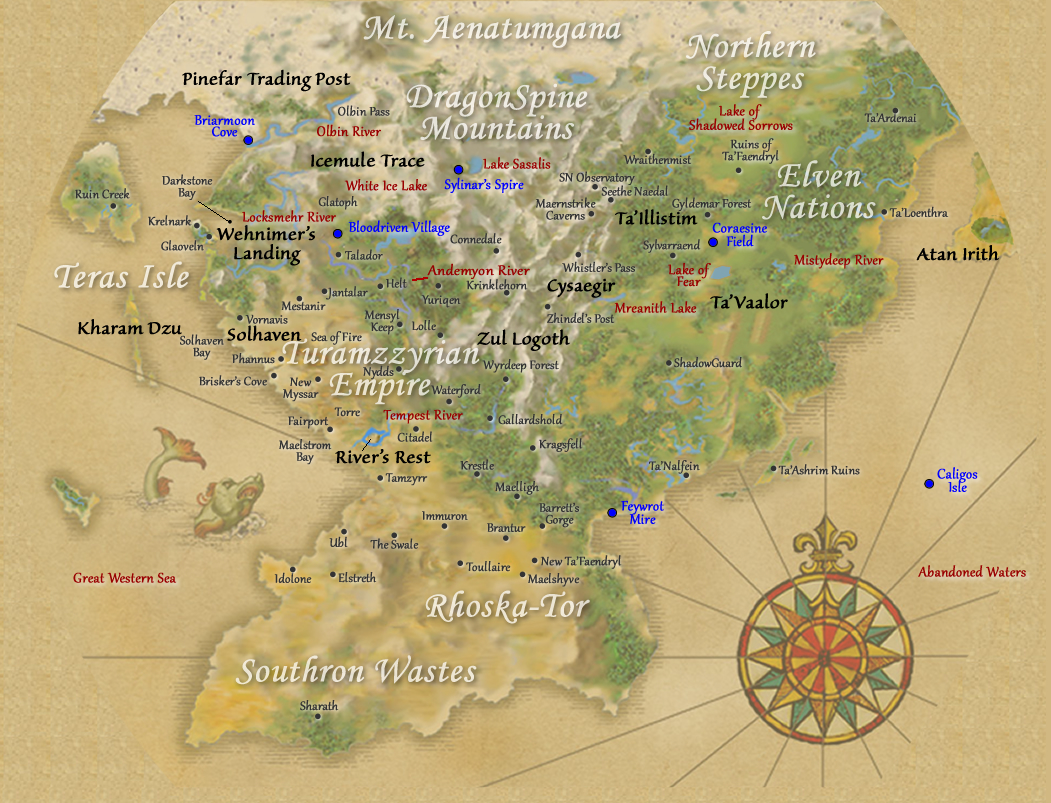
Elanith is the primary continent of Elanthia, and is home to the adventurers of GemStone IV.
Geography
Elanith lies on the northern hemisphere of the planet, bordered by seas to the west, east, and south. To the north the landscape becomes increasing frozen and inhospitable. The Dragonspine Mountains run north-to-south, bisecting the continent.
Western Elanith
On the northwestern coast lies the town of Wehnimer's Landing, a busy trading post on the edge of Darkstone Bay, which is fed by the Locksmehr River. Across the bay is the Isle of Glaoveln, controlled by krolvin pirate warlords, and beyond that the Great Western Sea. To the south of the town are the Dragonsclaw Mountains, with its four peaks from west to east: Wehntoph, Sentoph, Zeltoph, and Thanatoph. To the east are the Lyserian Hills, and further north are the high glaciers of Glatoph. A long and dangerous trail runs past the glaciers towards the lands of the Paradis halflings.
The main settlement in halfling territory is the town of Icemule Trace, which can be seen from the trail as it descends from the mountains into the forests around Snowflake Vale. Beneath the town itself are vast underground caverns. Frozen fields and arctic pine forests surround the town, and further to the north, beyond Olbin's Pass, is the Pinefar Trading Post at the foot of Mount Aenatumgana.
Southeast of Wehnimer's Landing are the baronies and counties of the Turamzzyrian Empire, the closest being Vornavis and Talador. The Freeport of Solhaven lies along the Vornavian coast, south of Cairnfang Forest.
To the east of Vornavis are other baronies, including Mestanir and Jantalar. The landscape becomes gradually greener eastwards, until reaching the boundaries of the Turamzzyrian Empire at the edge of an ancient aspen forest. Somewhere within the forest is rumored to be the sylvan city of Yuriqen.
Beyond Vornavis to the southeast lies a great desert known as the Sea of Fire, nominally part of the Empire but controlled mainly by the Tehir tribes. And even farther south, on the mouth of the Tempest River that flows down from the Dragonspine Mountains to the Great Western Sea, lies the town of River's Rest within the County of Torre. The town borders Karazja Jungle to the south and the the coral reefs of Maelstrom Bay to the west.
Westwards across the water, on Teras Isle, is the dwarven mining town of Kharam Dzu. The town is located beneath a great volcano known as the Eye of V'tull.
Further south along the coastline of Elanith is the Duchy of Selanthia with its great human city of Tamzyrr, capital of the Empire. Beyond Selanthia are various other baronies until the fortress of Barrett's Gorge at the far southeastern frontier. There the borders of the Empire end at the Demonwall.
Southern Elanith
The rocky wastelands of Rhoska-Tor are the site of unusual mana foci that alter the physical and magical natures of those who dwell there. Within are the ruins of Maelshyve, whose undead armies once threatened the entire continent. The city of New Ta'Faendryl, built by the Faendryl dark elves after their exile, lies north of Rhoska-Tor.
Farther south are the Southron Wastes, home to the Dhe'nar and their city of Sharath.
Eastern Elanith
The eastern half of Elanith was once entirely under the dominion of the elves, but has since fractured into independent city-states. Passage between east and west through the Dragonspine Mountains is controlled by the dwarven clans through the underground town of Zul Logoth.
Eastwards from Zul Logoth, a trade route winds through Whistler's Pass towards the elven city of Ta'Illistim, a haven of learning and scholarship. The wilderness areas on either side of the main trail are sparsely populated, with the glaciers of Gossamer Valley overlooking it to the west and the shadow of the Blighted Forest falling upon it from the east. The only notable settlement along the trail is the aelotoi town of Cysaegir. Closer to Ta'Illistim are the high peaks of Griffin's Keen, and the city itself lies at the foot of the Seethe Naedal with nearby caverns and hot springs.
A road runs southeast from Ta'Illistim towards the hamlet of Sylvarraend. North of the road is the Wraithenmist, ever shrouded in fog and shadow, and farther east is Gyldemar Forest with a scattering of abandoned elven outposts. Beyond Gyldemar are the ruins of Old Ta'Faendryl, home to strange interdimensional creatures and sealed behind a magical barrier.
Past Sylvarraend, the road leads to the edge of the Lake of Fear. On the other side, through Fearling Pass, the fortress-city of Ta'Vaalor stands overlooking the Mistydeep River. The elven legions still patrol the immediate outskirts of the city, but farther from its walls, within the farmlands and the Neartofar Forest, are orcish and troll encampments, and even farther the Plains of Bone and the Fethayl Bog roamed by spirits of the undead.
South of Ta'Vaalor, beyond the ruins of Shadowguard fortress, are the lands of the Nalfein elves, with their city of Ta'Nalfein along the southeastern coastline. Off the coast are the shattered islands that were once Ta'Ashrim.
Northeast of Ta'Vaalor are the other elven city-states, Ta'Loenthra and Ta'Ardenai, bordered by the Shirelands of the original halfling clans. Past those, the continent ends on a narrow sea, with the continent of Atan Irith somewhere beyond.
Places of Interest
- Wehnimer's Landing
- Solhaven
- Icemule Trace
- Pinefar
- Teras Isle
- Kharam Dzu
- Zul Logoth
- Ta'Illistim
- Ta'Vaalor
Behind the scenes
Several very old stories and NPCs refer to the continent as Jontara, with Elanith meaning the Darkstone Bay region.
